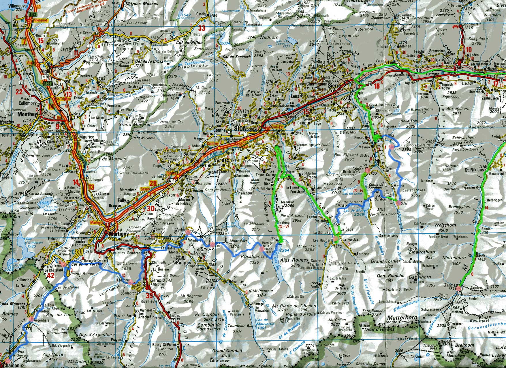
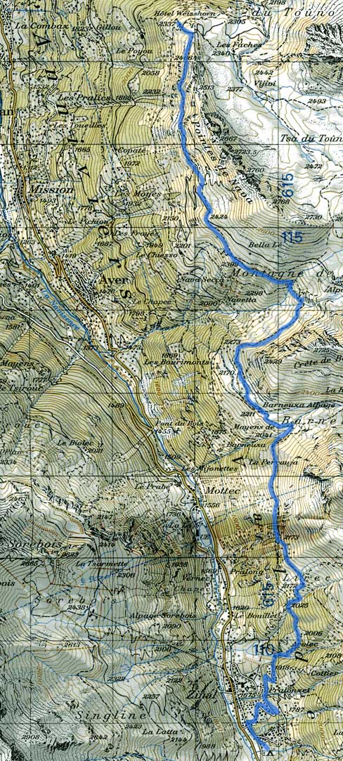
The route we took is marked below on the map, with the blue stretches indicating sections we walked, the green showing where we took the bus, lift or train, and the red circles showing where we stopped at night.
The day by day summary
Day 1 - August 9 Paris to Argentiere
Waking up at half past five is not usually a whole lot of fun. On this occasion we not only had to get up, but also to finish up the packing. No time for breakfast, but my uncle insisted on driving us to the train station. There was amazingly little traffic on the main thoroughfares of the city, and so it only took about 20 minutes to the get to Gare de Lyon. We were running a bit late though, so we had a somewhat frantic rush to find which train was leaving for Lyon.
We left on time for Lyon. Our trip across central France saw the sun steadily rise on fields, forests and small towns. I think we stopped twice on the way to Lyon: once in Mâcon, the other in St. Etienne. In less than 2 hours, we arrived in Lyon.
The Lyon train station was not a particularly exciting building. Nor for that matter was the street outside, mostly dug up and awaiting a new tramway system. Took us a bit of time to find the post office, where we sent a packet of photos to my uncles (didn't want to carry them along for the next 2 weeks). I also had my first encounter with a pay for service bathroom. Ah, modernity...
Our train to St. Gervais les-bains left around 9:30PM. This was not a TGV, but a normal (and rather slow) train. Still, we passed through a good number of attractive little French towns and the always green countryside, not to mention the steadily rising sun in an awfully blue sky. Around 11:30PM, we reached Bellegarde. This was surprising, since it meant we could have taken the later train to Geneva, and still arrived at the same time. Oh well.
After Bellegarde, the scenery became more familiar. We went through the rolling hills around Geneva, paused in Annemasse where our train split (for the second time, it'd already split in Bellegarde with the section to Geneva going off to the west). There were no friendly border police this time inspecting, and soon we were working our way toward large and impressively white mountains. However, the weather was somewhat hazy, which was a little irritating on such an otherwise fine day.
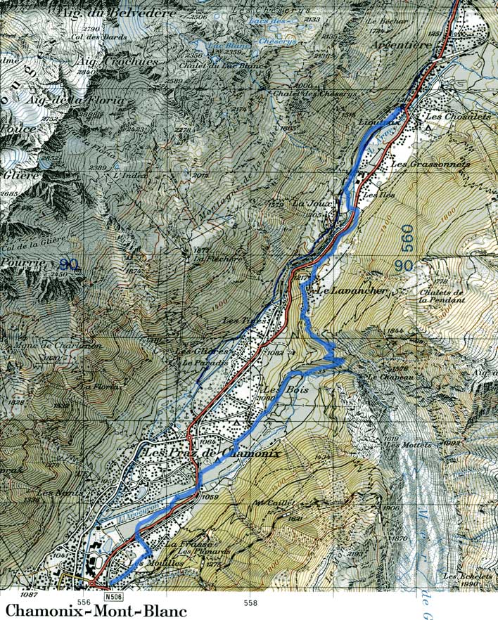
At St. Gervais, instead of a 20 minute break, we switched trains immediately to the red narrow-guage extremely full train to Chamonix. The ride up, though not new to me, was still exciting, with views of the Mont Blanc and other sights marred only by a man talking loudly on his cell-phone blocking the window. At 1:30PM, we reached Chamonix.
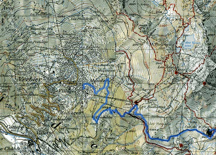
Chamonix was, as expected, a zoo. There were people everywhere, and it took a considerable amount of effort and concentration to navigate our way through the throngs in the streets. Finding suntan lotion was surprisingly difficult in this resort town, although the bakery was typically centrally located. Unable to find a battery for my newly dead altimeter, we decided to head onward for lunch. We made a somewhat circuitous path out of Chamonix, leading past the Chamoniard Volant, and then back across the road to a shady path by the river.
We had lunch around 3PM in the shade by the Arveyron. Our first lunch of bread and cheese for the trip. Left around 4PM, making an effort to stick to the shade. It was certainly warm enough outside. We kept to the paths marked 'Le Levancher' and 'Le Chapeau.' The trail ascended steeply, and yet when we finally crested around 5PM, we had passed a half-dozen cyclists on their way down.
Going down the other side, we quickly reached Le Levancher, a nice little village of mostly summer chalets. We also promptly lost the trail, and when it became clear that we were going to end up on the main road from Chamonix, we chose to follow a drainage ditch above the road. Finally, this too ended, and we crossed the river to a shady path on the other side.
Before 6PM, we'd reached the edge of Argentiere. We were in the process of figuring out which fork in the road to follow when I suddenly noticed the name of the building next to us: Hotel des Randonneurs. That was our hotel, so in we went. Then we resumed our tour of Argentiere, minus the sweaty boots. It was a reasonably lengthy town, so it took us about 10 minutes just to get to the center. Everything but the major shops were closed, so we spent a bit of time in the main grocery store and waited in a nearly epic checkout line to pay. We also discovered there was to be a concert that night, by a flutist Guy Angeloz, at the church at 9PM.
Hurried back to the hotel for dinner. Dinner was nice enough, served by a Canadian server who was up there for the summer (those Canadians), but it was painfully slow toward the end. We managed to nonetheless be at the church at the appointed time. There, Mr. Angeloz performed a dazzling array of short virtuoso pieces. He clearly was having a great time (didn't even need to look at the music he was playing), and the crowd enjoyed it too. Gave a little taste of all different genres of flute music, not to mention a demonstration of the piccolo and alto flute. Returned to the hotel tired and impressed, and went to sleep.

Day 2 - August 10 Argentiere to Trient
Got up around 7 for one of those (in)famous continental breakfasts. If you like bread, cheese, jam and the usual sorts of things, it was a good breakfast. So it worked well for us. Then packed the packs and made another pass through town, this time in search of maps. Tourism office had no helpful one. Neither did the little press shop that we waited for half an hour outside as the owner took his time opening up, though my father did pick us up some more bread.
The sun was still not up on much of the valley when we crossed in front of Argentiere's two churches to begin ascending the south side. There was almost no view, but the trees made pleasant company, and it took us half an hour of switchbacks to arrive at the next junction. There we actually began to descend as the trail finally emerged from the trees to go in the direction of Le Tour. Le Tour itself was a medium-sized village, with a lift-line going up toward the Col de Balme, and we arrived there at 10:30AM, having only met one other person on the trail (a mushroom picker).
At Le Tour, we followed the main trail up, which pretty much paralleled the lift line. There were loads of people there, and the sun was out in full force. Although it was a beautiful day, it was considerably hazier than the day before, and wisps of clouds had begun to form around the Mont Blanc. It took us just about an hour to reach the middle lift station.
Next, the trail left the lift-line, and proceeded on a less steep course toward the Col de Balme. We could see several other trails crossing the by now open pastureland, not to mention hikers and even 2 British bikers (who thought that the sign prohibiting bikes on the trail actually meant bikes recommended). The panorama opening before us included the Chamonix valley (and Chamonix itself), the Mont Blanc massif, and the less substantial range that marked the Swiss border.
The Col de Balme itself (2204m) was on the border and we reached it around 1PM. The border itself was a smallish stone with marks indicating 'Suisse' and 'France'. We walked across with nobody the wiser. Right on the other side was the Cabane de Balme, a cheerful looking mountain hotel/restaurant with large numbers of hikers milling around in front. The view was impressive, with a valley on each side: one leading to Chamonix, the other to Trient. We could see Les Drus, the Mont Blanc, and all numerous mountains on the other side whose names we did not know.
After a few minutes, we proceeded down the other side. Surprisingly, the vegetation changed from one side of the border to the other. The valley here was pockmarked with avalanche marks. Once we reached the treeline, we paused for lunch. We ended up sitting in the middle of what seemed to be a blueberry patch, to the considerable detriment of our clothes.
Continuing once we'd finished lunch, we made our way into the woods. We passed an enormous party of hikers not long after, and played an advanced version of leapfrog with them most of the way down. The trail itself became quite steep as we got farther down, and it took more than another hour of descent before it leveled out. Then, suddenly, we emerged onto well-tended pastures, and soon passed a number of strawberry patches.
The first town we saw wasn't Trient, it was Le Peuty. It was picturesque, small, and had not a single shop or hotel, only farmhouses and normal houses. We continued toward Trient, which, while unmarked on our map, was supposedly less than 10 minutes distant. It was in fact the next town that was Trient, a spread out, slightly larger town, which on closer inspection had a hotel, a cafe and a church. The cafe next to the church turned out to be where we were spending the night: the Café Moret.
We checked into the cafe quickly. It was more a cafe than a hotel, but apparently they'd had an addition of 5 rooms to the place, some years back. Our room was a bit spartan, but clean and with a nice back view of their garden and its lettuce. We also took a look about the town. The only shop in town was a sort of miniature general store, inside the other hotel. There we picked up food and a phone card. They had neither maps nor an ATM for cash in Trient. The church was nice enough too, and when some of the clouds above the town cleared, we had a view up a view of the mountains including a formidable glacier.
Dinner was impressive. Much of the salad actually did come from the garden, the soup was quite appreciated, and the main course was a good mix of vegetables and meat. We planned for the next day as well, since we were apparently still on the map (including Trient, which was marked, but not labeled). Finally, around 10PM we went to bed.
Day 3 - August 11 Trient to Champex
Our chances were looking pretty miserable when we got up this morning. Completely overcast skies. The rain had died down a bit, but it was still darn wet outside. We had breakfast in the dining room with a couple of other somewhat chagrined hikers. Our packs aren't really cut out for being rained on all day. Considered simply taking the bus to our next destination, but decided to try the store first. Picked up a large roll of garbage bags there, which we used to cover the packs.
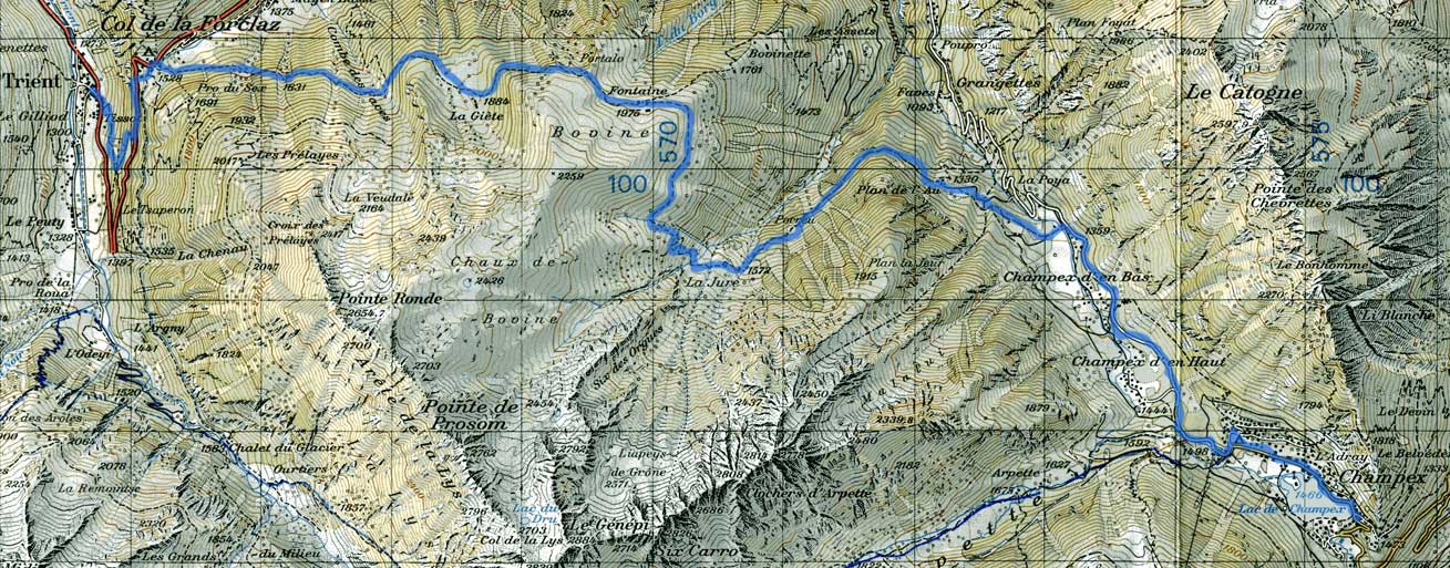
So, at around 9:30AM, with the drizzle having become merely fog, we set off from Trient. The trail was quite muddy, and quite steep too. We were plenty warm by the time the trail rejoined the main road, and we had a somewhat unpleasant time in the bike lane as cars going up to the Col de la Forclaz zoomed by.
At the Col de la Forclaz itself, we had a view of sorts. There was a hotel, a couple of houses, and a small shop, not to mention many cars and 2 tour buses. I took advantage of that shop to pick up a map of the area. Amusingly, this one covered all the way from Chamonix, so we could see our complete route to date.
From the Col de la Forclaz, the trail climbed steadily. The fog was thick, but every so often we caught glimpses of the Rhone valley and Martigny below us, seemingly just a stone's throw away. The hillside was reasonably well forested, so even the occasional drizzle wasn't too bad, although I almost slipped several times courtesy of the mud.
Around an hour up, three guys coming the same way caught up with us. In the course of asking whether this was the proper trail for Champex, we discovered they were from Boston. Small world. In the next hour we passed a number of small buildings, a field full of cattle and finally the trail crested giving us a view down to Martigny and toward Champex.
From the crest, we came out on a large meadow area, and after some fairly steep switchbacks down, we reached a farmhouse-come-restaurant. Apparently there were plenty of other hikers out too, many eating lunch there. We took what proved to be the ricketiest table there, and ordered röshti, the Swiss national specialty (a sort of baked potato dish). Hot food on a cold day with a view down 1500 meters to the Rhone river. Lunch was greatly enjoyed, despite the fact that we couldn't afford to pay in Swiss currency (they took euros though).
Around 1:30PM, we set off again. Our descent was leisurely enough until we reached a side valley, up which we could glimpse the foot of what I suppose was the Trient glacier. At any rate, to cross the 3 small rivers coming from it, we went down an extremely muddy collection of wet rocks masquerading as a trail. It wasn't fun, even though we were losing elevation a lot faster than I'd thought possible. At one of the streams, we stopped for a break, and watched as a train of donkeys and hikers made their way up. I can only imagine what the donkeys thought of the path.
After we finally abandoned this side valley, the trail leveled out again, and eventually broadened into a farm access road. We passed two large farmhouses where some young kids appeared to be having a very good time running around. Around 3PM, our trail departed the road, working its way gently up a side valley. When we reached a paved road by a little hamlet (too small to call a village), rain had begun to fall again.
Trying not to get too wet, we took the road past the tasteful village of Champex d'en Bas, and then a trail that took us over the top of some unnamed pass. We rejoined the road at a large parking lot, and finally, at nearly 4:30PM arrived in a town large enough to be Champex. Interestingly, though we found a market, the tourism office, and half a dozen hotels, the lake itself, of which we had heard a good bit, remained invisible.
When the lake did appear, it meet expectations: a grey blue oval surrounded by mountains on the once side and the town of Champex on the other. It had more than its share of small fishing boats and peddle boats out too. Our hotel turned out to be right at the edge of the far end of the lake, and we were given a 3rd floor room which not only had very nice wood panelling, bizarre lighting, and a private balcony (with a flag), but an obstructed view of the lake and much of the town. True, we are paying for it, but the Auberge de la Foret certainly gave us quite a location.
The next order of business was to explore the town and find the usual essentials. On the way to get these, we popped into a sporting goods store to see if we could find a new backpack for me (mine was a bit small, and lacking totally in internal support). We found something that seemed decent, although it later proved to have a belt that was too large, and a frame too small, so it wasn't exactly an improvement.
After this unlucky bit of near-impulse shopping, we were returning when we heard a very soft and mellow noise from by the lake. Upon closer inspection we found an outdoors alpenhorn (corps d'Alpe) concert in full swing. The 8 players and their magnificently large instruments were having a grand time despite the miserable weather (it was plenty windy, with a bit of rain now and again). A somewhat cold audience was seated on rocks and chairs nearby listening. We joined. 2nd concert this trip, in the last 3 days.
We returned to the hotel for dinner around 7PM, and I managed to offend the owner by asking to sit in a non-smoking area (he had none). We compromised by sitting in an area where nobody at the moment was smoking. Dinner was tasty, if somewhat overly meaty (literally). After that, there wasn't much to do but have a small walk outside and go to sleep.
Day 4 - August 12 Champex to Verbier
Up for an 8AM breakfast. The view from our room of the lake was gorgeous, especially now that the sky had turned mostly blue). We made a brief trip off to the store for various needed supplies (soap, apple juice, etc.) and then set off at 9AM. We saw the hikers from Boston on their way down too, although their plans to take the lift to Cabane de Mont Fort made us assume this would be our last meeting.
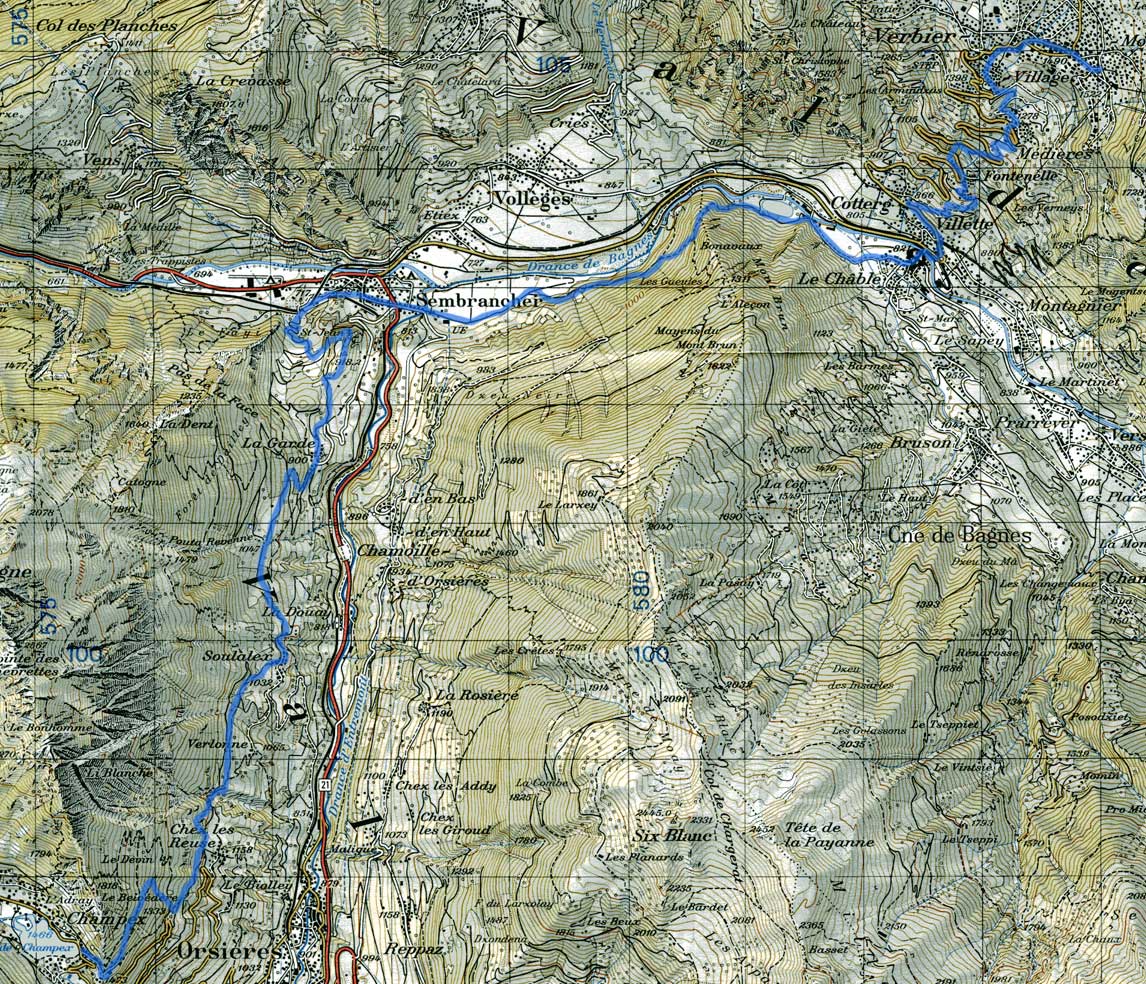
Our trail from Champex kept to the trees initially, descending rapidly into the Val des Bagnes. We bypassed Orsieres, instead keeping to the west side of the valley as we worked our way north. The weather became rapidly quite warm, and after half an hour, we were walking through pastures and by farms with a beautiful view of the valley.
We passed a number of small towns as we went along, all with a church and a fair amount of farming equipment, indicating that as picturesque and touristic as they seemed, they had real people living and working in them too. On we went.
On the other side of the valley, we could see all sort of farm-related activities taking place too. Some farmers were out cutting hay, others seemed to be burning refuse, and still others had set up massive sprinkler systems to water one or another crops. I didn't realize just how big these were until once, after about 2 hours of slow descent, we emerged on a field where a sprinkler was jetting water at least 30ft. up into the air.
Curiosity piqued by its name and apparent location, we attempted to visit the church of St. Jean. This involved a lengthy scramble to arrive at a closed church which probably looked much more impressive at night and at a distance. The descent from the church was quite impressive, however, in its steepness. An ill-chosen step would have been the beginning of a very rapid journey down to Sembrancher.
We did reach Sembrancher itself, a bit past noon. The town was quite nicely arranged, and after we crossed the main road to the Col de Grand St. Bernard, we had almost no traffic. We passed a few more farms, and farmers at work, before the trail rather abruptly reentered the woods and climbed up a considerable bit. The ascent made up for the shade.
Fortunately, before I was completely drenched in sweat we redescended to rejoin the river, having apparently avoided some rather eroded (and thus steep) hillside. We passed along a path which gave all sorts of information about Switzerland and its cantons, not to mentions a great view of an unfinished dirtbike park and a very picturesquely located dump.
Around 2:15PM, we crossed a branch of the river and emerged at an open field with a direct view of Le Chable, and particularly its church, not to mention various large unidentified snow-covered mountains in the background. We walked directly to the church, and on a stone wall outside, had our lunch.
Le Chable was our original destination of the day, but since we were already there, and the next to Mont Fort would be long, we decided to change our endpoint for the day, and make the climb up the side of the valley to Verbier. This would make the next day easier at the expense of the current one. So we bought some lens-cleaner (for my father's camera lens), crossed the river, and after several tries turned up at the tourist office, where a very nice lady not only found us a place for the night in Verbier but also canceled our previously made reservation in Chable.
The actual climb up to Verbier was something of an ordeal. The trail alternated between following the road and going its own way. The weather was warm enough, and direct sunlight made the climb brutal. At several little villages along the way we stopped and drank from the fountains. Nonetheless, up we went, and the views behind us became considerably grander, and more expansive. We almost lost the trail at least half a dozen times, but recovered it almost all of them. Finally, in a village not far from Verbier, we lost it for good, and continued on our own and arrived at a small church with a shrine in front.
Verbier itself is sort of suburban sprawl in the Swiss alpine style. An enormous collection of ski chalets and hotels more than an actual town, it sits below a number of supposedly very nice skiing areas, with a reasonable view down on the main valley. Finding our hotel was of course slightly difficult in such circumstances, but with a little perseverance and the help of a lady walking her dog, we arrived at the Hotel Mirabeau. First hotel we visited where there was no demi-pension dinner. Our room was third floor, and the hotel seemed almost empty.
We had a couple of odds and ends to do anyway, so once the packs were off and some of the sweat washed off, we went back out. Since my altimeter's battery died in Chamonix we've been looking for a watch shop that might carry it. Wandered into a rather funky electronics shop, and to my amazement, they carried it. Was even pretty cheap. The hard part was successfully opening my watch to change the dead one for the new one.
For dinner, we went to Fer au Cheval, a pizza place just 2 blocks from the hotel. Interesting atmosphere, especially since we were sitting in the lower level near the kitchen. Good dinner, supplemented with quality ice cream for dessert. Who said food on the trail has to be bad? Spent a bit of time at the phone booth and then went to bed.
Day 5 - August 13 Verbier to Cabane de Mont Fort
With breakfast at 8:30AM, we had little incentive to get up. Breakfast was in a very curiously arranged dining room. Afterwards, we made our typical inquiry about the weather before setting out into the town. Our errands were many. Call my mother back home (for the first time in a week, oops). Did that with surprising little difficulty. Send off our excess baggage in a box to my uncle's in Paris. The packs are too heavy. Disposed of almost 6 pounds of stuff, mostly out of my pack. At the food store picked up supplies for the next 2 days (it'll be that long 'til we're in a town with stores again). Needed some skin cream too, since the mountains have been drying us out. Finally, popped by the tourism office for some less than helpful weather and trail info.
By the time we'd packed everything up and bid adieu to the Hotel Mirabeau, it was almost 11AM. Late start. Finding the trail, as always when leaving a big town, required a good bit of luck. Unfortunately for us, the trail chose to follow a skiing access road, and was marked quite infrequently. After 15 minutes of level going and no markers, we assumed we'd missed a turnoff, and took the next pseudo-trail we found.
This was something of a mistake, since we ascended exceedingly steeply, and then began looping back in the direction of the town. The trail ended when we reached another, almost-level road. It took a good while before we reached a junction with trail signs again, and by this time we'd gone a long distance out of our way. The route back was a hillside traverse, entirely in the forest, and lost most of the elevation we'd already gained, finally leading to the village of Clambins where we joined the real trail that we'd earlier abandoned. Still, we had good views of the Val de Bagnes on the way, not to mention various colorful mushrooms.
From Clambins, the we continued up a much steeper path, past a couple of Chalets. We remained in the woods, although the day outside, partly overcast, was hardly any warmer (or brighter). For a ski route, the trail was pretty steep, and it seemed to go up without end. Finally, we emerged above the treeline onto a trail that seemed also quite popular with bikers. Suddenly, we came over a little hillock, and had a view of the Les Ruinettes lift station. From just below the station, we watched as over a dozen paragliders launched toward the Val des Bagnes. It was around 1:30PM.
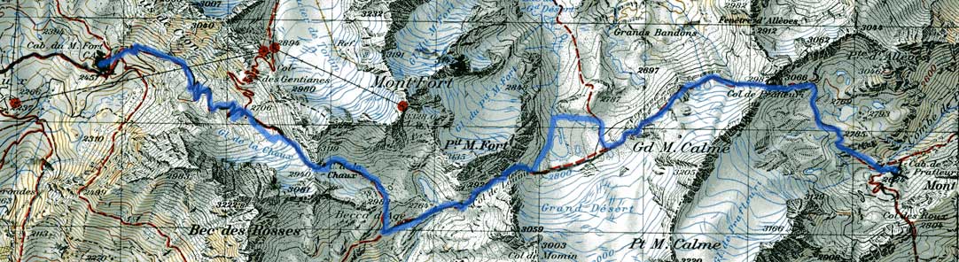
After a good rest watching the colorful parachutes descending on Verbier, we continued. The trail leveled out to the point that I again wondered if we'd missed the correct trail, but wisely continued without comment. We spent almost an hour traversing through high pastures before turning uphill again and began to work our way up a side valley. We passed near a lift station, under a lift line, and eventually crossed what appeared to be an access road. The Cabane de Mont Fort was pretty easy to see, perched prominently on a hill, but the trail nearly circumnavigated the hill before finally rejoining the access road (again) for a short steep ascent to the hut.
Swiss cabanes (or huts) as they are called are effectively mountain hotels. Run usually by the Swiss Alpine Club, you can usually get meals, and beds in the dormitory, but not too much else. The Cabane de Mont Fort appeared to have been quite recently remodeled. Not only that, but they had rooms, rather than one or two large common dormitories. Ours even had a view of the Val des Bagnes, and the once again visible Grand Combin.
Since we had no plans to go any further, after we arrived (3:30PM), we unloaded our packs, got some tea in the common room, and wrote, read or photographed for the rest of the afternoon. Rest was of course nice (we'd come up 1000 meters), but it almost became a little dull by the end of the day. Once my immediate aches and pains resolved themselves, and I'd finished my postcards, there didn't seem a whole lot left to do.
Dinner fortunately interposed itself, and considering that we'd had no real lunch, it was extremely welcome. The eating arrangements were also peculiar for a hut: no attempt was made to aggregate people into table-sized groups so the experience was like that of a restaurant.
By the time the sun was setting, the sky was mostly clear, and we had a most amazing view to the west, including a dusky reddish tinted collection of rocky cliffs and glaciers that a friendly hiker told us could only be Mont Blanc. After 4 days of hiking we still haven't escaped that mountain. We went to bed well-rested and well-fed.
Day 6 - August 14 Cabane de Mont Fort to Cabane de Prafleuri
Got up to an amazing sight. The sun was rising on the mountains to the west of the Val des Bagnes, which included a distant Mont Blanc massif, and a less distant Grand Combin. I took a great many photos, even before breakfast. Breakfast itself was excellent, served by the same cheerful hut manager as dinner the night before. We took a last look at the Cabane de Mont Fort, around 8:30AM, and set off.
The trail began as simply being the access road to the upper lift station for the Mont Fort lift, and as such was a relatively gentle climb. The sky began blue, but became progressively covered with clouds. We were in the shade too, so the climb was quite cold. Near the junction we passed an intrepid biker, going up toward the lift.
After the junction we were on a more typical, rocky sort of trail, going in the general direction of the Col de la Chaux. The trail was marked in blue, not red, which surprised, but did not alarm us. What did surprise us was the the trail seemed to be going in the general direction of small glacier, and soon we were scrambling over rocks embedded in ice. At some point, we decided to abandon the trail as marked, and try and work our way around (not over) the glacier. Doing this, we discovered a second trail, far above the other, with the more typical red markings. This we took to the Col de la Chaux (2940m) arriving around 9:30AM.
We had a short rest at the top, and a snack, before attempting to go down. It was clouding over above. We immediately lost the trail (again) and had a dickens of a time finding it afterwards. Still, after a lengthy scramble, we did find it, and by around 11AM we had worked our way across a rocky bowl, and down a part of a ravine, to a point where we had another view of the Val des Bagnes including a little sliver of the Lac des Mauvoisins.
The next pass, the Col de la Louvie, was fortunately a shorter climb, up a much better marked trail, mainly because it passed through meadows and not simply loose rock. We reached the Col de la Louvie around noon, with near gale winds ripping through the pass, and a sky getting darker by the minute. As we slowly descended toward several unnamed little lakes below a largish glacier, the drizzle began.
Drizzle wouldn't have mattered too much, but the fog began to descend at the same time, making visibility doubtful. Meanwhile, finding the trail was a pain, not the least because it diverged noticeably from the route marked on the map. The area was all moraine anyways, so it wasn't as if the trail would have been clear without the blazes to begin with. With a great deal of guesswork, and considerable luck, we crossed a small bridge below the lake, and recovered the trail such that it was.
After a brief, sharp, ascent, the trail more or less plateaued. Being rained on didn't make the experience very fun, but at least the fog wasn't so low as to remove all visibility. Then, instead of reaching the pass, as I'd long expected, the trail dropped off into another bowl, with more glaciers, and more small unnamed lakes. We lost the trail again, this time, I thought for good, and had a very unpleasant ascent over loose rocks and all the rest. We were quite tired, and it was slow going up.
Courtesy of some sort of miracle, we did find the trail, right below the Col de Prafleuri (2965m), and soon reached our 3rd pass of the day. A few photographs later and we were going down the other side, trying to avoid sliding in the slick mud. Going down was once again more difficult than going up. The weather at least began clearing though, so we could see the whole Val de Pralfeuri. This included a rather nice lake, a glacial plateau, and various other features. More interestingly, I nearly walked into an ibex (bouquetin) ambling down the hill. Finally some wildlife.
Unfortunately, it was past 3PM when we reached the plateau, and the cabane, our destination, was not visible. It took another half an hour before we could see the cabane, which was a good bit lower than we expected, sitting with a view of the valley, on the edge of a very narrow ravine.
When we reached the Cabane de Prafleuri, it was with great pleasure that I took off my wet shoes, socks and jacket, and laid them by the heater. We relatively quickly arranged for our beds and meal. Unlike in Cabane de Mont Fort, the rooms were not private, but we were given 2 beds in an 8 bed room, where only 2 others would be expected.
Once mostly dry and unloaded, we went down into the nice warm common room to have apple pie and tea. Outside, it was beginning to not so much rain as snow, and in a matter of less than an hour, the ground had become quite white.
Dinner here was served family style, which meant that we were paired with a very nice French family from Sion, who were up for the weekend. Snow in the middle of August had not been their plan either, but chatting was fun, especially when one is warm, and in the process of becoming well-fed.
Partway through the meal, a British couple arrived and joined our table. Much to our surprise they were doing the same route as us, but in reverse. We compared notes, and they gave us good ideas for the next few days, although all was highly weather dependent. They must have had a dickens of a time getting over from Arolla to the Cabane, climbing up 1300m and 17km in one day, as well as receiving all the rain and snow that we had.
It was very nice to be able to go to sleep in a building in the process of once more being encased in fluffy white blanket.

Day 7 - August 15 Cabane de Prafleuri to Les Hauderès
We awoke this morning, hoping that the weather might have improved. It hadn't. Clouds shrouded the little valley, and a layer of fresh snow covered the landscape as far as we could see. Unhelpful. Breakfast was held at half past 7 downstairs, and was quite ample. Both the family from Sion and the British couple were down there too. They all planned to go down to the of the Lac des Dix, and leave from there. We, on the other hand, were unsure if we could still hike all the way to Arolla. It was all dependent on how bad the snow was, and how the weather would stay.
Thus after we packed and payed, we headed out, but not by the route the others took. We worked our way uphill in the direction of the Col des Roux, 150 meters above the cabin. Of course, there was the obvious problem of finding the trail. It disappeared rather promptly, and aside from very occasional blazes, we were more or less on our own. Slogging uphill in snow is certainly very picturesque, but it's also good hard work, not to mention a great way to slip and sprain an ankle. Between our 3 walking sticks we managed, and I only had 2 major falls. Still, it was almost an hour of climbing before we crested the Col des Roux around 9AM.
From the Col we had the view of a sort of winter wonderland. Below us, 400 meters below, was the Lac des Dix, one of Switzerland's largest lakes. As far as the eye could be, the mountains were covered with snow. We couldn't even see the top of most of the higher mountains, shrouded in a massive cover of grey clouds. What with the wind gusting through and blowing snow everywhere we left quickly.
Descending to the Lac des Dix was a much longer proposition than I'd expected. The trail was actually partially visible, so we spent less time floundering in deep snow (almost a foot deep in spots coming up). Still, it was lengthy, and my father's leg was becoming a serious problem, apparently somewhat overstrained from the previous week or so of hiking.
When we arrived at the Lac des Dix, we'd more or less given up the chance of hiking to Arolla. With the snow, the iffy weather, and my father's rotten luck, we decided to go down to the end of the lake and take the bus from there. At the junction with the lakeside trail, we headed north towards the dam. The spectacular rock, snow and cloud scene didn't change too much, although we were now being drizzled on occasionally too. The trail went through a fair number of tunnels too, most unlighted, and several quite long with leaks inside. A very peculiar experience.
We reached the head of the dam surprisingly tired for the end of a half day's march. It was a truly enormous dam, and descending to the bottom was nontrivial, a matter of 200 meters or so in steep narrow switchbacks. We encountered almost 50 people in the process of going up, so I suppose the walk around the lake is reasonably popular too. The bus stop was part of a complex (too small to be a town, and no houses) called Le Chargeur, which included a very unappealing looking hotel (basically a '60s era office building, highly un-Swiss), a food kiosk, and a museum with exhibits on the dam. The bus hadn't yet arrived, so we learned a bit about the dam.
On the bus, we got a ticket to Sion, not realizing that we actually only wanted to go as far as Vex. We met the British couple we'd seen in the morning also on the bus, so we had a pleasant trip down, even if we didn't pay much attention to the scenery. We also had a pseudo-lunch of zweibeck crackers and dried apricots (we traded the one for the other with our neighbors). At Vex, we realized (suddenly) that we needn't go all the way to Sion, and got off. It was 1PM, so the town was completely closed, and we waited 40 minutes for the next bus to Les Hauderes.
When we saw the bus would also go to La Sage, we figure to go there instead, since it was basically the start of the next day's stage. When the bus passed through Évolene, we saw a very curious looking parade, which turned out to be part of the mid-summer's celebration. At Les Hauderes, the bus paused briefly, before making the final ascent to La Sage.
La Sage was not quite what I had expected. It was a small town. Midsummer's was apparently a cantonal holiday, so the tourism office was closed. The only hotel in town was closed for renovation (very closed, most of the visible rooms appeared full of construction materials). There was a restaurant with dormitory space, but my father was looking for something with a bath tub. We thought of going down to Les Hauderes, but were afraid it'd be full on account of midsummer's. We had a reservation in Arolla, but getting there would hard, since if we took the bus down, we'd miss the bus to Arolla. Unhelpful.
Eventually, we determined to walk down to Les Hauderes, in spite of my father's discomfort. It was a slow walk, through the woods, with a constant drizzle. At Les Hauderes, I made a quick dash to the tourism office, which was of course closed. Worried about missing the bus to Arolla, I went into the first hotel I saw, and asked if they had rooms available, with baths. They did. Thus we spent the night at the Hotel des Hauderes, probably one of the fancier hotels in town.
The room was nice, but the most immediate attraction was the hot bath, and the large beds. We rested. But before getting too comfy, I ran down to the shoe repair shop I noticed, to see if something could be done to shore up the by now nearly detached soles. The cordonnier wasn't too optimistic, but he said he'd try, after he got them dried out (which would take time).
Dinner was fancy, but I was not especially impressed. The person serving seemed ill-at-ease, and the meat-centric meal was filling, but less than I'd hoped for (no good salads or things like that). Afterwards, we spent an inordinate amount of time loafing outside in town, waiting for the payphone to become available. Despite the wait, we did not reach any of the people we were trying to call. Called it a day not long after.
Day 8 - August 16 Les Hauderès to Grimentz
Got up this morning with no idea where (or whether) we'd be going anywhere. Depending on weather, my father's leg, and half a dozen other factors. Had breakfast in the dining hall, a fact complicated by a partition which closed about half of the area off. Breakfast itself was a queer and somewhat uncongenial affair, owing to the matron who seemed somewhat offended when we asked for tea and coffee (a practice we've been doing for the past week plus).
Once breakfast was done, my father took a taxi to the next town to visit the doctor, while I did various small tasks, It was shaping out to be a marvelous day: the clouds and rain had cleared up leaving clear skies, and a considerable sprinkling of fog at the higher elevations. I packed the packs, bought a map of the region (sure have spent enough money on maps), and waited for my father to return.
He returned, having had a pleasant, if less than satisfactory visit with the doctor. At least now we have some type of painkiller with us. At any rate, he determined that we should continue on, so I picked up my boots from the cordonnier (he wasn't committed to finishing them before the evening), and we waited for the bus to La Sage and Le Villa. Around 11AM, we arrived in Le Villa.
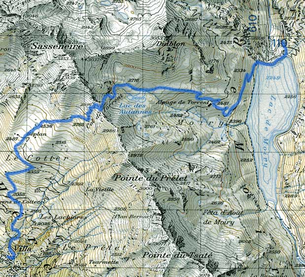
The trail going up to the Col de la Torrent had two great virtues. First, it spent almost all of the ascent going up soft grassy hillsides. And secondly, when it was clear, it afforded amazing views of the Val d'Heren. After less than an hour, we had climbed up sufficiently that we could see a formidable array sharp white glacier encrusted peaks. Moreover our view stretched along the valley as well, from what might well have been Arolla, down to Sion.
Fortunately, the day after a storm is usually relatively cool, and this was no exception. The ascent was hot, and there was no shade, but we had the benefits of a light breeze and low ambient temperature. Many other hikers were taking advantage of the weather as well, including in a woman, probably in her late sixties who bid us a cheerful hello, and announced that she was going at the pace that suited her. Should I ever reach such an age, I can only hope to be that upbeat and committed.
Still, it was a steep climb. At several points we passed windsocks, and frequently observed paragliders that had just taken off. We never did find the launch site, but in a shallow bowl we passed a number of curious rock formations and a small pond beside which various cows were placidly resting. The snow started around 2500 meters, but it was so slushy that mud was by far the greater nuisance, as the path transformed into something of a streambed.
At any event, we reached the Col de Torrent (2919m) just before 3PM. A ridge of dark stone, all the darker from the contrast with the nearly fresh snow, the views from the pass were incredible. On the other side was the Lac de Moiry, a peculiarly greenish cast of blue. Beyond that was another range of mountains, frosted white, with increasingly massive glaciers as you worked your way south. Behind us was the Val d'Heren, but one could also see the higher mountains by the Lac des Dix. We were very impressed.
We had a leisurely and late lunch on top of the pass, on a little ledge of rock. Around 4PM we started the descent. There was more snow on this side, and the going was slow. In one area we saw a perfectly smooth patch of snow, with a set of pawprints leading across it. We passed a small lake too, and a farm house which advertised fresh cheese, although we did not try to get any.
For the night, we were planning in staying at the Auberge de Moiry, a place recommended by the British hikers we'd seen at the last cabane. I gave them a call on my cell-phone around 5:30PM. Of course they were full. Meanwhile, the last bus to Grimentz, the nearest town, had already left.
We weren't quite sure what to do, and my father's leg had become troublesome coming down. Rapidly we traversed the lake, arriving at the dam and the nearest road. A pair of women were in the process of leaving the parking lot, and so without much hope we asked whether they had space in their car and could possibly take my father to Grimentz. They very graciously offered not only to do that, but to take me as well. The drive down to Grimentz was quite a relief, therefore, and the folks who'd picked us up were quite friendly and even went so far as to recommend a hotel. Everything was working out well.
Not only did that hotel have space, but the rooms were quite nice, and we had an opportunity to unload, before going out to explore the town. It appeared to be a very well-preserved town, with many houses up on those funny wooden stilts, with giant flat rocks to keep rats from climbing up. Ingenious not to mention picturesque. We wandered through quite a bit of the town, including the church and the tennis courts, picking up a very friendly cat who followed us for quite a distance.
We had dinner in the hotel restaurant, and since we were too late for the demi-pension, we got raclette instead. The fact that the cheese was heated on the roaring fire that they had in the center of the dining room only improved the effect. Dinner was both filling, and intellectually stimulating, since it was our first occasion of having raclette à la Suisse, in a very long while. We went to bed well satisfied.
Day 9 - August 17 Grimentz to Zinal.
Slept quite well last night. The breakfast in the hotel was quite a bit more congenial than the one we had a day ago though. Very relaxed, with morning sunlight streaming in, and a steady stream of folks coming in to grab their coffee. We were actually a bit in a hurry, but even that couldn't ruin the atmosphere. After paying (surprisingly reasonable considering the raclette we'd had the night before), we headed off for the post office to wait for the bus.
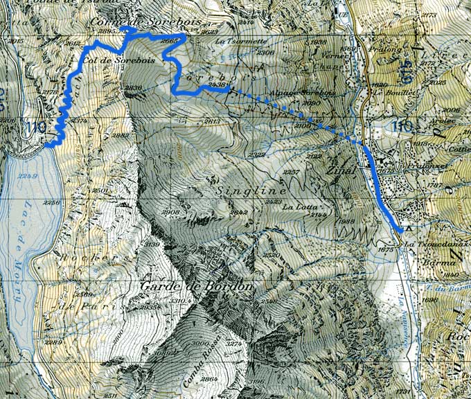
The bus to the Barrage de Moiry didn't begin full, but once we'd made our second stop, there were basically no empty seats, and I had a large backpack sitting on my lap. The sky outside was clear and the weather a bit cool as the bus made its winding way up to the dam. The view, from the dam, was superb. The Lac de Moiry was no longer the color of an overchlorinated swimming pool, but rather an almost perfect mirror for the surrounding, still snow-capped, mountains. We started at 9:30AM.
Our trail got right to business, combining short traverses and narrow switchbacks to go up rapidly. We lost the shade in no time, and had to stop to apply a good layer of sunblock. After about an hour of this climb, sweating profusely, we got our first view of the pass, several hundred meters above where I thought it was supposed to be. No matter. The trail remained passable, though steep, to the top. We saw a good many people coming down as we approached the top, which was something of a surprise.
At the Col des Sorebois, we saw that the other side had a ski lift going part way up, and a trail continuing up the ridge, a few hundred meters, to a peak of sorts. We followed it up. The Corne des Sorebois had the closest thing to a 360 degree panorama we'd had in the trip. Unfortunately, there were also a lot of other people on top, not to mention a fair quantity of pretty fragrant goat droppings. Still, we couldn't pass up the opportunity to take a vast number of photos. The medium-format camera once again came in handy. We had amazing views of the Zinalrothorn, the Weisshorn, the Dent Blanche, and even the Dent D'Heren, not to mention the Lac de Moiry and the Val D'Anniviers going all the way down to Sierre and the Rhone. It was a sight.
Still, after a snack, it was only about noon, and we were off again, descending down the other side toward Zinal and the lift. It was a steep rocky trail, probably a ski run as much as a hiking route. Still, it got us down, and around 1PM, we arrived at the middle lift station, from where we could take a lift directly down to Zinal. Considering my father's shin, and the fact that it was getting quite hot, I had no problem taking the lift down.
The lift ride was short, and let us off in the middle of Zinal. We had the original idea of continuing on to the Hotel Weisshorn for the night, but that proved impossible, as it was full when we called. So after some thought, we decided to stay in Zinal. Our hotel, reserved more than two weeks ago, was the Auberge Alpina, at the other end of town. This required a surprisingly lengthy walk.
The hotel itself was a smallish building adjoining a camping area, with a good-sized restaurant and outdoor section. The owner was a cheerful fellow who showed us our room, and then went back to bar-tending whistling an unfamiliar (to me) tune. Unfortunately, we soon discovered that the lock on the door was very unhappy with the key we'd been given (and the key oddly worked fine in the door of the room next door). The manager insisted that it was the right key, and observed that 'there's a trick to getting it work, but I don't know it.' After some fumbling and experimentation we figured out how the door worked.
For lunch, we wanted a scenic place in the shade. This was easier said than done, but after a shortish walk, we had made our way through a small farm, up to an nature observation center, and onto a small rock. The bread, cheese and apple juice proved a good lunch, even if some of it had come all the way from Verbier.
Going back through the farm after lunch, we passed a horse, numerous donkeys and a very friendly (and hungry) pig who was most disappointed that we'd brought nothing for it to eat. We walked up the valley for another half hour, crossing over just before the trail began to seriously ascend. We had a good view of Zinal from the end, though not of the glacier in the other direction. Oh well. The walk back was in a very peculiar sort of twilight.
We had a few odd errands in Zinal, so we ended up going back through town on a side street. This time we saw the old houses and chalets (not just the newish shops). We made a phone call too, frustrating some folks who wanted to use the phone by an admittedly long (though important) call to Geneva.
When we returned to the Auberge Alpina for dinner, the restaurant was basically full. For the 30 or so people there, there was still only the one fellow who we'd seen in the afternoon. He served, chatted and cleaned with the flourish of a virtuoso. The tables too, we now noticed, were all different shapes and sizes, and almost no two chairs matched. The decor of the building fit in well: a mix of posters for old productions and peculiar black and white photographs. As for the dinner, it proved to be a great salad, a huge serving of lasagna, and ice cream for dessert. The only hard part was paying at the end, since the server was flitting all over the place at a speed very hard to catch. We went to bed immediately afterwards.
Day 10 - August 18 Zinal to Hotel Weisshorn.
Between unhelpful weather reports (storms in the afternoon) and untimely injuries (my father's shin), we decided not to go to Gruben today. Still, up early enough for breakfast. The proprietor of the Auberge Alpina seemed to have disappeared, but after some complications, we found somebody to pay. Definitely one of the most affordable nights. Bid our somewhat peculiar resting place farewell around 8:30AM, and were on our way.
Our path began passing through Zinal, and past some of the ugliest (and largest) skiing condos that I'd seen. Our trail began steeply enough, switchbacking through alternating forests and meadows. In a bit more than an hour, we gained 500 meters. Our views of Zinal, and the surrounding mountains grew broader even as the thin wisps of white we'd seen earlier began to metastasize into dark clouds.
Once the trail leveled out, the route became a lengthy traverse along alpine meadows with a more or less constant view down the Val d'Anniviers towards Sierre. The route was also longer than it might have been on account of the side valleys, one of which took 3/4 of an hour to work around. We only saw a single farmhouse and a few cows, not to mention a handful of hikers, which left most of the route to ourselves.
Gradually though, the terrain became rockier, and finally we passed along a massive avalanche zone just as the Hotel Weisshorn came into view. We chose to have lunch around 1PM on a nearly hidden bench with a clear view of the other side of the valley.
We hadn't made much progress with the bread and cheese when it began drizzling. We slowly finished our lunch, and reached the main junction by the Hotel Weisshorn when the rain began coming down in earnest. So in we went.
The rooms weren't due to be ready until 3PM, so we had dessert (their famed blueberry tart) and tea as we waited. The rain outside was certainly coming down, and their dining area was full of hikers of all brands, waiting either for their rooms, or a let-up in the storm. I even began writing my long neglected trip journal as we waited.
Once the rooms were ready, there was a fresh complication. Just as the day before, the key didn't open the door. Less surprised this time around, my father fiddled with it enough to figure out the trick. Old doors apparently have these problems.
Later, after a shower and a rest, we had time to admire the hotel as a whole. It claimed to be founded in 1882, which I'd certainly believe from the noise the floorboards made, not to mention the fact that no rooms included bathroom or even a sink. Nonetheless, once we headed down for dinner around 7PM (I spent the rest of the afternoon writing) you could definitely see that the hotel still took itself seriously.
The servers were all formally dressed, and the dinner was multi-course, served on real table clothes. They apparently had a quite large selection of wines, though we didn't try any. The salad was appreciated, but the main course, meat and fried potatoes, was less welcomed. Dessert turned out to be the same blueberry tart we'd had for lunch. Oh well, it was certainly tasty. After dinner there really wasn't much to do besides pack and go to to sleep. Before 9PM.
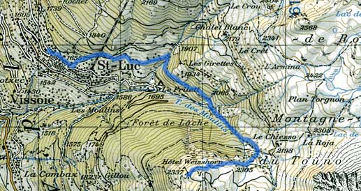
Day 11 - August 19 Hotel Weisshorn to St. Luc and Zermatt.
Pretty grey outside this morning, though the storm clouds have mostly disappeared. Day began (as usual) with breakfast, down in the Hotel Weisshorn's magnificent dining room (well, the view were almost magnificent). Next we paid (one of our more expensive nights), and set off downhill for St. Luc.
The walk down was nice enough, but the time pressure (trying to make a 9:50 bus) weighed down a bit, as did the knowledge that our hiking journey was basically at an end. Sigh. Trail was freshly damp, but not too muddy, and not too steep either, so when we arrived in St. Luc, my father's ankle wasn't bothering him too much.
Before getting on the bus, we managed to pick up bread, postcards and a general hiking map that listed proposed tours of the Valais region. For next year perhaps? The first wrinkle of the day was the bus, which wouldn't accept our Eurail Pass. I'm surprised. We changed once in Vissoie to a very full bus (every seat, basically), and arrived in Sierre in less than an hour, after a slightly windy and jarring ride, that involved driving over several sets of train tracks (the main entrance to the station was closed).
At Sierre, I learned our passes were also no good for the Visp-Zermatt section of our route, so we had to buy even more train tickets. Not impressed. Took the regional train from Sierre to Visp, which meant plenty of stops. At Visp itself, we stopped for nearly 40 minutes, waiting for the next train to Zermatt. In normal times, it's probably a nice place to stop, but this station too was under construction, and the noise of heavy equipment, plus the fences that kept you from exploring in most directions were not congenial.
The train to Zermatt didn't seem to have changed since we'd taken it 2 years before. The major difference was the fact that high clouds obscured most of the mountains, so the only view one had was of the valley itself. Around 1PM we finally arrived at Zermatt.
Finding the hotel was pretty easy, but finding the front door was less so. Mischabel was an old establishment, and from the unobvious front entrance to the high ceilings and lack of elevator, it wore its age as a badge of honor. We left our backpacks, taking only a small collection of odds and ends for our late lunch.
Trying to find a good picnic place was a much more complicated task than intended, We took numerous little side streets in hope of a view only to find ourselves at a dead end with no exit save by going all the way back. Eventually we landed on the trail to Zmutt, but here too there wasn't much of a view, owing to clouds, and the Matterhorn was completely invisible. After 20 minutes on the trail, we gave up and found a large rock to sit in. It was a favorite rock of a great many ants as well, so lunch too became complicated.
During our return, the clouds opened up a bit, and we had, in fact, a very brief view of a chunk of the Matterhorn. Still, we were more than a little disappointed. Before dinner, we made a couple of stops in little shops for gifts and postcards, as well as lengthy phone calls to plan out tomorrow.
Dinner itself (our 9th demi-pension of the last 11 days) was enormous. Moreover, since they didn't have any small bottles of water or juice, the drinks were also enormous. I don't know how they make money there, but I sure hope they do. After dinner, we made another phone call, and I somehow managed to lose our list of important phone numbers. In a bid to reconstruct it, we tried out their internet kiosk, but aside from checking my e-mail through the web and depositing lots of change, I got nowhere. Overstuffed and tired, I went to sleep around 10PM.